On a recent walk to the mercado just two blocks north of our apartment, the street name, Mártires Irlandeses, caught his attention. "Irish martyrs in Mexico?" he asked, looking at me quizzically.
The next street is Heroes de 47. Just a few blocks farther, the Metro Station at the corner of 20 de Agosto Street, is named General Anaya. At the other end of 20 de Agosto Street is the Museo de las Intervenciones (Museum of the Interventions).
By now, my curiosity was piqued as well: What did these street names refer to? Irish martyrs in Mexico? 1847 is the year of the Mexican-American War, which Mexicans call the Intervention, but what is the significance of August 20th? Our visit to the Museum of the Interventions uncovered yet another many-layered Mexican story.
 |
| Captain John O'Reilly, Commander of Saint Patrick Battalion, 1847 |
In a small plaza in front of the entrance, we come upon a monument that reads, in part,
"To the memory of the illustrious and brave Mexicans who fought in defense of their country and made the sacrifice of their lives in this very place, August 20, 1847."
Mystery solved: The Convent is the site of the Battle of Churubusco during the Mexican-American War.
The Spanish invasion of Mexico was a military campaign fought to gain total control of this new land, Nueva España, and its people on behalf of the Spanish king. As a military commander, Cortés sought to consolidate and protect his control of Mexico City, built atop the ruins of the Aztec capital, Tenochtitlán, on an island in the middle of Lake Texcoco.
 |
| Causeway (straight, green line) built by Aztecs to gain land access from Tenochtitlán, Aztec (or Mexica) capital situated on the large island (red-tinted shapes, center of the map) in middle of Lake Texcoco, runs straight to Huitzilopochco (orange-tinted shapes, southwest). |
The map clarifies the strategic value of Huitzilopochco. Its location on the southern causeway enabled the town, established in the eleventh century A.D., to control access to the Aztec capital from the south. By constructing the Convento de Churubusco, Cortés, in turn, was able to control southern access to Mexico City. It is said that Churubusco is somehow the Spanish mispronunciation of Huitzilopochco.
As a point of interest, the curved, blue lines on the map represent dikes built by the Aztecs to keep brackish water from mingling with fresh, spring-fed waters surrounding their island capital. The dikes are another example of Mesoamerican engineering expertise.
Churubusco's strategic location proved to be important again some three hundred years after the Spanish Invasion and construction of the Convent in the town of Huitzilopochco.
 |
| Battle of Churubusco, August 20, 1847 |
As part of U.S. President Polk's plan to take parts of Mexico by waging war, the U.S. invaded Veracruz, Mexico in March 1847. By August, U.S. forces were approaching Mexico City. On August 19, Mexican troops were defeated at Contreras, south of the city. They retreated to the convent in Churubusco to defend the main road—atop the ancient causeway!—that led straight to Mexico City, capital of the Republic of Mexico.
 |
| U.S. Battle Map for Churubusco |
The settlement at the bottom of the map is Churubusco. Mexico City lies straight north, connected by a roadway that still follows the ancient Aztec causeway. In 1847, the road passed through the marshes that were all that remained of Lake Texcoco, after the Spanish had drained the lakes centuries earlier to prevent flooding and disease.
But the U.S. did not delay; instead, they pressed their attack against the Mexican troops the next day at the Convent of Churubusco and obtained their surrender.
 |
| Captain John O'Reilly commanded St. Patrick's Battalion, composed mostly of Irish and other Catholic deserters from U.S. Army opposed to the U.S. invasion of Mexico |
After their defeat and capture, survivors of St. Patrick's Battalion were hung as traitors. Today they are honored in Mexico as Los Mártires Irlandeses de '47.
 |
| In plaza just outside convent, statue honors General Pedro Maria Anaya for his valient defense of Mexico during the Battle of Churubusco. |
 |
| Los Niños Heroes (The Boy Heroes) |
Less than a month after the Battle of Churubusco, the U.S. attacked the Mexican military citadel, the Castle of Chapultepec, located on what were then the outskirts of Mexico City. Among Chapultepec's few defenders were teenage cadets who fought to the death. They are honored in Mexico as Los Niños Heroes.
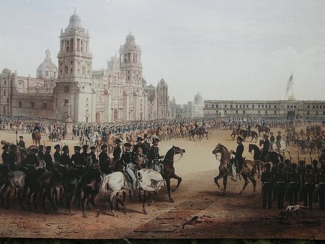 |
| U.S. General Winfield Scott (mounted on white horse) enters the Zócalo, Mexico City's major plaza. U.S. flag flies over Mexico's National Palace. |
In mid-September, General Winfield Scott entered Mexico City and took control of the government.
 |
| Metro train departing General Anaya station |
Today the ancient Aztec causeway, dominated by the Spanish Convent of Churubusco in the sixteenth century and captured three centuries later by U.S. forces in 1847, is the eight-lane Calzada de Tlapan, which runs not far from our home. As did its predecessors, it takes modern-day Mexicans to and from the heart of Mexico City.
General Anaya Metrobus Station is a block from the ex-Convent of Churubusco, its gardens of paradise and its battlefield.
Housed at the ex-Convent of Churubusco, the Museum of the Interventions relates the histories of Mexico's four major interventions.
The Pastry War (December 1838-March 1839): A French Pastry Chef claimed 600,000 pesos for damages to his shop ten years earlier—a claim that might have been ignored, except that Mexico had also defaulted on its debt to France, which predisposed the French king to send a fleet to blockade Mexican ports and seize Veracruz on the Gulf of Mexico. The U.S. sent a schooner to assist the French with their blockade, which was lifted when the Mexicans promised to pay their debts, which they did in a timely manner.
Mexican-American War (1846-1848): President James Polk was determined to acquire California in order to assure U.S. access to seaports and trade on both oceans. Polk first sent an emissary to Mexico City to offer to buy the territory. When the Mexican government refused to sell, Polk determined to take the land by force.
Mexico had never accepted Texas independence after Texas's Rebellion against Mexico in 1836; thus, Mexicans were infuriated when in 1845 the U.S. annexed Texas. Using this unresolved dispute with Mexico as a pretext, Polk sent troops to the Rio Grande—disputed territory. When Mexico retaliated for this incursion, the U.S. declared war and invaded Mexico on three fronts:
Museum of the Interventions
Housed at the ex-Convent of Churubusco, the Museum of the Interventions relates the histories of Mexico's four major interventions.
The Pastry War (December 1838-March 1839): A French Pastry Chef claimed 600,000 pesos for damages to his shop ten years earlier—a claim that might have been ignored, except that Mexico had also defaulted on its debt to France, which predisposed the French king to send a fleet to blockade Mexican ports and seize Veracruz on the Gulf of Mexico. The U.S. sent a schooner to assist the French with their blockade, which was lifted when the Mexicans promised to pay their debts, which they did in a timely manner.
Mexican-American War (1846-1848): President James Polk was determined to acquire California in order to assure U.S. access to seaports and trade on both oceans. Polk first sent an emissary to Mexico City to offer to buy the territory. When the Mexican government refused to sell, Polk determined to take the land by force.
Mexico had never accepted Texas independence after Texas's Rebellion against Mexico in 1836; thus, Mexicans were infuriated when in 1845 the U.S. annexed Texas. Using this unresolved dispute with Mexico as a pretext, Polk sent troops to the Rio Grande—disputed territory. When Mexico retaliated for this incursion, the U.S. declared war and invaded Mexico on three fronts:
- Northern Mexico was invaded from the North, by U.S. troops crossing the Rio Grande (Rio Bravo to Mexicans),
- The Mexican Territory of Alta California was invaded from the East by troops arriving overland through New Mexico; and from the West by the U.S. Navy, which had been sent to the Pacific for this express purpose;
- Mexico was invaded from the East by Marines landing in Veracruz on the Gulf of Mexico; subsequently, the U.S. Army under General Winfred Scott invaded Mexico through the port of Veracruz. The Battle of Churubusco occurred as part of this military campaign.
Mexican Revolution (1910-1917): The U.S. intervened twice. In 1914 the U.S. sent a fleet to blockade the port of Veracruz to prevent delivery of German arms to the Mexican president. In 1916, in retaliation for a raid by Pancho Villa on Columbus, New Mexico, President Wilson sent Gen. John J. Pershing with 5,000 troops into Northern Mexico to capture Villa, who successfully evaded capture.
 |
| Grand Old ahuehuete Tree, National Tree of Mexico |
In the same plaza, not far from the monuments commemorating the Battle of Churubosco, stands this ahuehuete tree, a Montezuma cypress, sacred to the Mesoamericans and now the National Tree of Mexico. This grand, old tree stands tall against the elements—an encouraging and reassuring presence.


