Yes, Mesoamerican cities are often very intentionally designed. God-kings were in charge and served as 'chief priests'. The pyramids and temples (such as Pakal's 'Temple of the Inscriptions' at Palenque) were built not only as tombs of the kings, but to honor as well the god the now-deceased king had represented on earth.
Pakal directed the building of his own tomb, and his son had the finishing touches put on it. The son then built three more "temples," honoring himself, his royal lineage (traced back to a mythical founding by the gods in 3000 B.C.), and each of the city's three chief gods.
Pakal's tomb at Palenque
Note the Nine Levels representing the Underworld
Note the Nine Levels representing the Underworld
The Mesoamerican 'city plan' is a representation of the cosmos—a 'cosmogram´—laid out to the four cardinal directions. Imagine a cross formed by two lines: one connecting north to south, and the other connecting east to west, with a center point located at the intersection of the two lines.
Mesamerican astronomer-priests had observed the sun's daily path east to west across the Heavens, and they posited that the sun's zenith (high noon) fell directly above the center located in the plaza. Similarly, they posited that nightly the sun traversed the 'Underworld' and that the sun's nadir (midnight) passed below the center point located in the plaza. In this sense, they envisioned a spherical planet.
This center point serves as an axis mundi (world axis) that connects the Human Level vertically down to the Nine Levels of the Underworld and up to the Thirteen Levels of the Heavens of the Gods. The Mayas regarded the ceiba tree to be the Tree of Life, with its roots in the Underworld and its branches supporting the Heavens.
Ollín (Sp. el movimiento) is an ancient word that translates into Spanish as 'the movement'. In English, perhaps 'motion' is the best interpretation. Ollín refers to the motion that is the Life-Force itself. Not surprisingly, ollín was said to occur primarily along the axis mundi or World Tree, which permits 'movement' from one level to another—especially by priests in altered states of consciousness.
For this reason, Mesoamericans typically constructed at the plaza's center point a pyramid surmounted by a temple; the steep 'rises' and short 'runs' of the stairs leading to the temple at the top symbolized the 'motion' of ascending to the Heavens. Subterranean rooms (tombs and rooms dedicated to ritual performance) were often found at the base of pyramids, such as Pikal's tomb (discussed below).
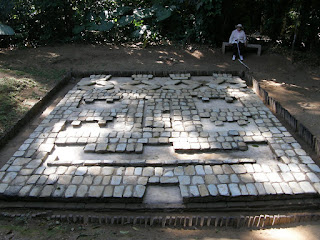
'Cosmogram' at Toniná
The 'cosmogram' on the pyramid at Toniná explicitly portrays this plan. It is composed of a lower pyramid—the Underworld—and an inverted pyramid above—the 'stairs' to the Heavens. The vertical, central rectangle is an axis mundi—possibly the Milky Way—that unites the two supernatural worlds and the world of humans, which is represented by the horizontal band in the middle. The path of the sun—from east to west—is marked by the symbols on either side of the horizontal band.
The number of levels of the pyramids often reflect one or the other of the levels of these two 'supernatural' worlds. Pakal's tomb at Palenque, for example, has Nine Levels, representing the Underworld. The pyramid at Chichén Itzá (see below) has Thirteen :evels and a total of 365 steps on its four sides, representing the solar year. Pyramids and temples are often oriented to mark the four cardinal directions (north-south-east-west).
Ballcourts—the other central feature of Mesoamerican cities—were sacred spaces where the mythic battle between the Gods of Creation and the Gods of Destruction (the Underworld) was constantly replayed.
Ballcourt at Monte Alban
Ballcourt game between a lord—in the role of the Creation God—and dwarfs of the Underworld portrayed in miniature on temple stairs at Yaxchilán
The designs developed over a period of more than 2,500 years. Although their sites were not fully organized cities, the Olmecs (1,200-400 B.C.) were the first to design center spaces (plazas) with pyramids and ballcourts.
In Mesoamerican culture, the Jaguar is a God of the Night and Underworld. This mosaic was deliberately buried by the Olmecs beneath their plaza at La Venta. The plaza itself represented the primal sea from which the gods of creation brought forth the terrestrial world.
Monte Alban is considered the first fully developed city (500 B.C. to 500 A.D.).
The central plaza at Monte Albán
Contemporaneous with Monte Albán, Teotihuacán (north of Mexico City—a future trip, we were there in 1994) is the biggest city of all and was clearly designed from the beginning according to this cosmic plan, with a north-south axis for its huge so-called "Avenue of the Dead," and pyramids and temples aligned to the cardinal directions. Residential streets were laid out on a Manhattan-like grid around the political and ceremonial center.
The so-called Classic period Mayan cities came later (400-900 A.D.) and seem less formally organized. Palenque actually doesn't have an overall, clear plan. The palace is in the center, dominating the plaza, but the city is built along the base of a ridge, and a number of temples line up along that ridge. Other temples are arranged around the palace.
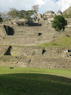
Each Mayan city we have visited—both this time and on previous trips—is quite individual in its layout. Perhaps this is because many Mayan cites are in hilly country, so the landscape determined their layout. Toniná (500-900 A.D.), for example, is in a wide, flat valley, but sited on a hill that dominates the valley. Its temples and palaces are almost all constructed on a pyramid built up the side of the hill, evidently for strategic defensive reasons.
This may be because of an invasion by the Toltecs, who dominated central Mexico after the decline of Teotihuacán and whose own city of Tula (900-1200 A.D., also north of Mexico City), imitated the formal organization of that earlier metropolis. The Toltecs invaded the Mayan area when it was going into decline and built, or influenced the building of, the later—and more famous—part of Chichén.
The Aztecs formed the last Mesoamerican civilization (1300-1521 A.D.). These nomadic, "chichimeca" ("barbarian") newcomers to Central Mexico imitated the formal urban planning of Teotihuacán and Tula in building their own city of Tenochtitlán (Mexico City). The plaza of Tenochtitlán became the Zócalo of Spanish colonial Mexico City, with the Roman Catholic Cathedral replacing—and built from the stones of—the "Templo Mayor" (here seen at rear center).
Each Mayan city we have visited—both this time and on previous trips—is quite individual in its layout. Perhaps this is because many Mayan cites are in hilly country, so the landscape determined their layout. Toniná (500-900 A.D.), for example, is in a wide, flat valley, but sited on a hill that dominates the valley. Its temples and palaces are almost all constructed on a pyramid built up the side of the hill, evidently for strategic defensive reasons.
Yaxchilán (350-800 A.D.) is similar to Palenque, built along the side of a ridge parallel to the Usumacinta River. It has a plaza lined by temples, but no free-standing pyramid as such. Most of the temples are above the plaza, on the side of the ridge; on the other side of the plaza the land slopes down to the river.
The stairs up to the main temple
Comalcalco is on the flat coastal plain of Tabasco state. It has a large, rectangular plaza, with a pyramid at the south end and temples arranged formally around the other three sides. However, there is a low hill at one corner and a large palace sits atop the hill, dominating the city.
Comalcalco
Uxmal, in the low Puuc hills (more precisely "hillocks") of the northwest Yucatán Peninsula, consists of a pyramid not in the center but to one side, with a variety of groupings of government and religious buildings spread out in a beautiful manner that seems determined by the gently rolling landscape.
Chichén Itzá, not far from Uxmal, but in the flat Yucatán coastal plain, presents both less formal and highly structured areas. The older part (600-900 A.D.) is built in the same, less formal "Puuc" style as Uxmal. But the newer part (900-1200 A.D.) is very similar to Teotihuacán, with a huge pyramid in the center of a huge plaza, a gigantic ballcourt and other buildings arranged in a rectangle around it.
Uxmal ballcourt, with "Nunnery" in background
Pyramid of Kukulcan at Chichén Itzá
Statues of Warriors atop the Pyramid at Tula


No comments:
Post a Comment