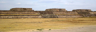
Introduction: This post, third in our series on Teotihuacán, considers the architectural complex that houses the Temple of Quetzalcóatl. Other posts in the series are I. 'City Where the Gods are Made' and II. The Shape of Space and Time, IV. Temple of Quetzacóatl and V. Palace Murals.After walking the Avenue of the Dead, Pyramid of the Moon and Pyramid of the Sun, we climbed the staircase of the gran plataforma (massive wall) enclosing la Ciudadela (The Citadel). Yet another monumental plaza spread out before us—la Ciudadela—so named by the Spanish when they came upon the ruins.
The Citadel was built during Teotihuacán's second phase (150-250 CE), roughly a century after construction of the Pyramids of the Moon and Sun.
 |
The four temples on the west wall of the Citadel feature staircases that give entry to the plaza from the Avenue of the Dead. |
Fifteen temple bases are ranged around the massive walls of the gran plataforma, which both encloses and defines the Citadel's plaza space.
- Avenue of the Dead (North-South) represents the axis mundi; as such, it symbolizes the World of the Spirit;
- East-West Avenue has been determined by archaeological excavation and by Rio San Juan, whose course the Teotihuacanos altered to align it with the path of the sun across the sky, perpendicular to the Avenue of Dead; thus, the East-West Avenue represents the World of Humans defined by the rising and setting of the sun.
Ciudadela: Layout
The Citadel consists of a group of fifteen temples arranged around a grand plaza equal in size to the plaza in front of the Pyramid of the Sun. Like the earlier Pyramid of the Moon, the Citadel's courtyard is sunken and enclosed by a massive stone wall (gran plataforma) along which range the bases of temples now lost to time.South Building: Seven Layers of Ruins Reflect Teotihuacán's Entire History
Another temple is located at the bottom of the GoogleMap satellite photo (south). Named merely the South or Southeast Building, this temple is not open to the public. I'm including it because I was struck by this remarkable description of its murals.The internet site Templo de Quetzalcóatl is the source for the following fascinating information (my translation).
Oldest Remains: Excavation has revealed a residential complex at the oldest, lower-most level. Built long before the Citadel was constructed, these original ruins formed the foundation for pyramid bases subsequently built atop them. Facing west, the pyramids featured stairways to temples located at their highest level.
Substructure 2: Excavation has uncovered the remains of a temple and staircase delimited by pottery remains, decorated with green and black concentric circles, around a red center. The body of the temple base presents talud tablero design. On the tablero are remains of a painted wall, with crosses formed by red superimposed rectangles framed by black lines. Inside the crosses appear three concentric circles that represent raindrops or precious green stones (jade or obsidian). The entire figure forms the quincunx—four points of a square or rectangle and a center that represent the cosmic structure (cardinal directions and a center).
 |
| Ciudadela South Building: Diagram of image found on mural. |
The presence of these remains of an early residential complex at the site where the Citadel was subsequently developed is suggestive. Not to be ignored is the possibility that the site was significant from Teotihuacán's earliest settlement period—a notion supported by the mural depicting the quincunx found in the South/Southeast Building.
Concluding Thoughts
By siting the Citadel at the quincunx formed by the city's two avenues, the city's priestly and ruling elite established the 'sacred setting' for Teotihuacán's religious and political power. When the Citadel was completed, the ruling elite then moved the city center from the Pyramid of the Sun south to the Citadel, and they inhabited the residential complexes around the pyramid known today as the Temple of Quetzalcóatl.Still Curious?
Link to Google Map of the Citadel. The white block in front of the later west facade built in front of the original pyramid is the canvas-covered entrance to archaeological exploration of a tunnel, first explored in 2010, that extends east under the Temple of Quetzalcóatl. Stay tuned for reports of their findings!Teotihuacán is a UNESCO World Heritage Site: http://whc.unesco.org/en/list/414
Teotihucán Zona Arquaeológica: http://www.gobiernodigital.inah.gob.mx/mener/index.php?id=30


No comments:
Post a Comment